
What is Satellite Geometry?
Satellite geometry is a critical factor in determining the accuracy and reliability of GPS positioning. The Global Positioning System (GPS) relies on a network of at least 24 satellites orbiting the Earth at an altitude of approximately 20,200 kilometers. These satellites continuously broadcast signals containing timing data and orbital information. To calculate its position, a GPS receiver must receive signals from multiple satellites and use trilateration to determine its distance from each satellite.
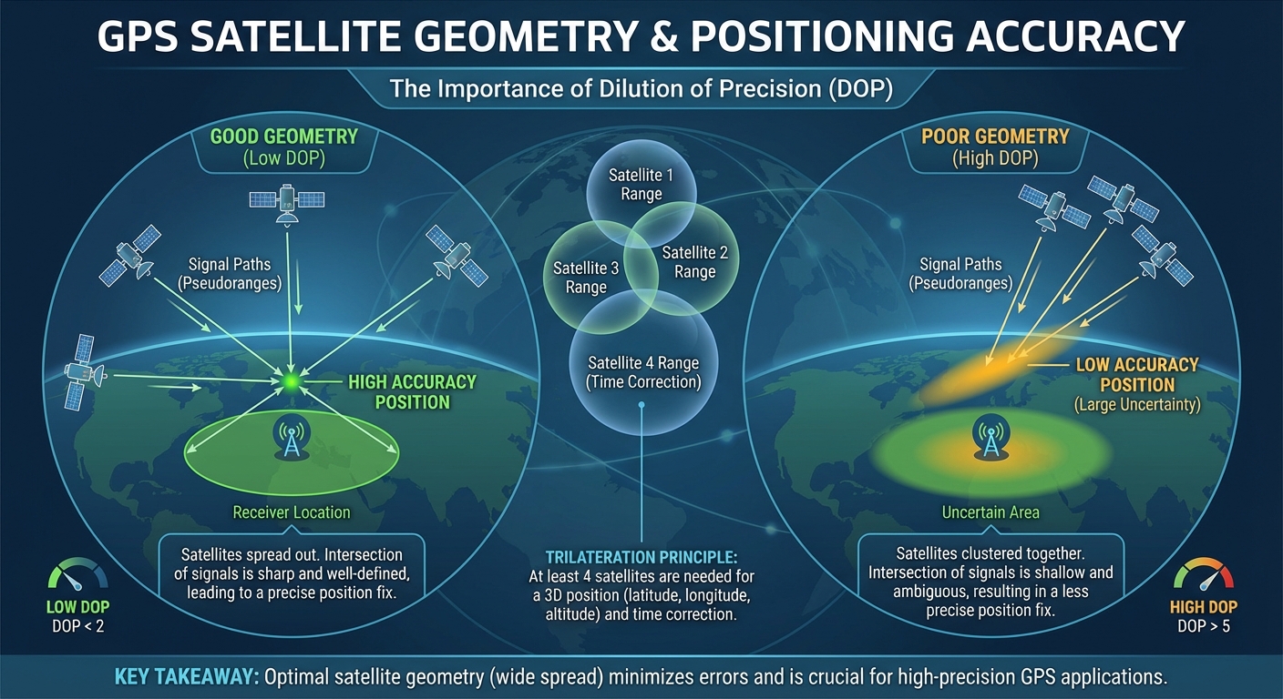
How Satellite Geometry Affects GPS Accuracy
The relative positions of the visible GPS satellites in the sky have a significant impact on the accuracy of the final position calculation. Satellites that are spread out across the sky, forming a wide geometric pattern, provide better accuracy than satellites that are clustered close together. This is because the wider the angles between the satellites, the more precisely the GPS receiver can determine its distance from each one, leading to a more accurate final position estimate.
Factors in Satellite Geometry
Several key factors influence the satellite geometry and, in turn, the GPS positioning accuracy:
- Number of Visible Satellites: The more satellites the receiver can connect to, the better the geometry and the more accurate the position calculation.
- Satellite Elevation: Satellites at higher elevations (closer to the zenith) provide better geometry than those near the horizon, which can be obstructed by buildings, mountains, or other obstacles.
- Satellite Distribution: Satellites spread out across the sky in a wide, even pattern offer the best geometry for accurate positioning.
- Satellite Signal Strength: Stronger satellite signals result in more precise distance calculations, improving the overall position accuracy.
Improving Satellite Geometry
To enhance the satellite geometry and improve GPS positioning accuracy, several techniques can be employed:
- Assisted GPS (A-GPS): A-GPS uses data from cellular networks to provide the GPS receiver with information about the current satellite positions, improving the time to first fix and overall accuracy.
- Differential GPS (DGPS): DGPS uses a network of ground-based reference stations to calculate corrections for GPS satellite signals, compensating for errors in the satellite geometry.
- Receiver Design: Advances in GPS receiver technology, such as multi-constellation support and enhanced signal processing, can help mitigate the effects of poor satellite geometry.